South Africa’s land legal environment is a complex one to navigate, governed by a myriad of legislation. However, given the country’s pressing socio-economic demands, this is the essential starting point for all infrastructure planning and project preparation.
IMIESA speaks to Karl Hoffmann, director and attorney at HSG Attorneys Incorporated, about the most effective approach.What are the primary objectives?
KH There are various key objectives, some historical – in terms of addressing the spatial inequalities of the pre-1994 spatial landscape, like land restitution, the Constitutional right for any person to own land – and others now more immediately directed at supporting South Africa’s economic reconstruction and development programme, and the roll-out of projects driven by South Africa’s Infrastructure Fund. The latter was already gaining momentum before the Covid-19 hit but is clearly even more of a priority in tackling the socio-economic fallout, helping to refocus the drive towards meeting the goals of the 2030 National Development Plan. A further development is the proposed Expropriation Bill.What role do land audits play in the process?
They are essential. A land audit is a process of identifying and investigating the properties that are affected by the intended development/infrastructure project. This audit process includes confirmation of ownership information; obtaining title deeds, notarial deeds,servitude documents, and mortgage bonds; a spatial analysis using a Geographic Information System (GIS) to detect possible tenure conflict and ensuring that there are no restrictive conditions of title
that could affect the subdivision/consolidation of land, registration of servitudes, or the development of the project. Zoning and/or
land use confirmation is also required.
Is the land legal process well understood by municipalities?
Projects should only go out to tender once the land legal checklist has been ticked off. That includes environmental impact assessments. However, the land legal step is often missed. Too often, the weighting is on completing the engineering design and starting the project. But if the contractor arrives on-site without a proper land legal process and agreements being in place with the landowner concerned, unanticipated tenure disputes will put the brakes on construction once the owner files an interdict. That will contribute to cost overruns due to standing time claims. The negative impact of delayed service delivery can also not be ignored. The time taken to complete the land legal process may seem time-consuming; however, doing it correctly will actually help further down the project line to ensure that projects are completed within their planned timeframes. The government refers to ‘shovel ready’ projects, but has the land legal side been completed?Is establishing or transferring land ownership or the registration of land rights a straightforward process?
From a legal standpoint, ownership and the acquisition of land rights and/or property, and its subsequent sale, transfer and/or registration, has always been an intricate process. The legal framework is governed by who the buyer and seller are. So, the first question to ask is, “What is the tenure?” For example, is the seller a private or public entity (like an SOE, national department or municipality)? Or is it a tribal authority negotiating the sale of a land parcel to make way for a greenfield construction development – a case in point being Sanral’s N2 Wild Coast project, where we have been involved from a legal perspective. In another example, a water pipeline needed to cross a school property in rural KwaZulu-Natal so confirmation was required from the landowner, which was the Provincial Department of Public Works. But because it was a school, we also had to get the consent of the Department of Basic Education. There may also be conditions on a title deed that restrict certain actions. For example, the land occupant may not be the owner, such as in a land invasion scenario. Or there might be a tenure conflict on a proposed pipeline route due to existing servitude rights and/or expropriation. An example might be an existing servitude owned by Eskom, with a section expropriated by Sanral. In another scenario, an earthworks contractor might accidentally hit an existing pipeline; however, its position would have been verified beforehand if the title deed had been checked for registered servitudes. And where there’s an unreported deceased estate, that estate is frozen. The potential heirs might also not be traceable.Is there a place for land expropriation?
Across the world, land expropriation is an accepted practice in preparing the way for infrastructure projects that include roads, rail, water, and sanitation. However, it intensifies within the South African context. Either way, expropriation should be the last resort where negotiations with the owner are unsuccessful.
When it comes to the implementation team, who’s on board?
The whole process works best with a holistic, multidisciplinary approach. Key team members include: – registered land surveyor – registered town planner – professional valuator – conveyancer with speciality in land legal matters – communications specialist, plus community facilitators/negotiators to ensure proactive public participation – GIS specialist – project coordinator – project manager.Why is accurate GIS data so important?
GIS is a tool used by the full project team. You can take the engineer’s pipeline design, overlay that with information provided by the land legal team, and automatically identify the land parcels that the proposed infrastructure runs over. Using a GIS, the specialist and surveyor can also identify infrastructure deviations that may require additional servitudes or acquisitions. These deviations are then checked on the ground to ensure that an accurate representation is captured. Our recommendation is that project planners base their decisions on up-to-date aerial photography. This can also prove invaluable in legal disputes. An example would be where a land invasion occurs after constructionhas commenced.
Can you provide an example that illustrates the value of pre-project preparation?
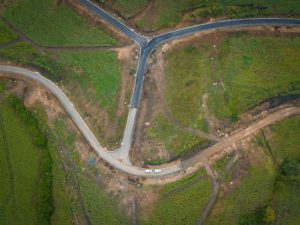
A classic one is the iLembe Water and Sanitation Pipeline Project. The latter serves as an excellent example of how the land legal process either comes together perfectly or becomes bogged down if the vital pre-project preparation checklist is not followed. This project entailed the acquisition of servitude rights for the installation of water and sanitation pipelines. Land acquisition was also required for the associated reservoirs and pump stations. The latter are regarded as subdivisions, requiring planning permission before proceeding with the transfer process. The project involved all forms of acquisition, including expropriation. In addition, the pipeline routes needed to cross under privately owned sugar cane farmland. This necessitated the appointment of sugar cane valuers in addition to property valuers. The purpose of the sugar cane valuers was to determine the loss of harvested income by the owner during any seasonal interruptions caused by the construction programme. The value of the servitude also had to be determined and negotiated. Various deceased estates were identified and, due to the lack of a comprehensive land audit being undertaken prior to the appointment of the contractor, these estates led to substantial delays and damages.And in closing?
The South African government has placed major emphasis on an infrastructure-led economic recovery. For this reason, strict due diligence is required to ensure a smooth land legal process. It’s a step-by-step process that cannot be circumvented. And when done correctly, it will speed things up further down the line.