While the Flanders Environment Agency VMM (Vlaamse Milieumaatschappij) in Belgium can do little to change the volatility of the weather, it does play a decisive role in creating a water distribution strategy.
The environmental agency measures and monitors water quantity and quality as well as manage water systems and levies fees on water pollution and groundwater extraction. It also advises on environmental permits, supervises infrastructure planning and supplies drinking water. VMM relies on IoT solutions and adopts an integrated approach that focuses on limiting the risk of flood damage and achieving a high ecological status. VMM looks to ensure that no user or consumer in the complex system of water distribution is neglected. However, one can only monitor something that has been accurately measured. User-friendly with low maintenance measuring equipment In the early days, ultrasonic sensing was used to measure the water level in non-navigable streams, canals and rivers. However, this measuring method had a major drawback, especially outdoors: the sound propagation time depended on the temperature, which resulted in considerable measurement errors due to temperature changes or solar radiation. Thick fog, wind and rain, as well as buildup of dirt also influenced ultrasonic measurement. Even cobwebs caused inaccurate readings, as they gathered debris that interfered with the measuring signal and resulted in an increase the blocking distance, or dead band. There were also ongoing maintenance problems. Radar sensors, by contrast, are not bothered by dirt, sunlight, fog, wind or rain. They also do not require mechanical protection from high floodwaters. For that reason, the decision was made over 15 years ago to change the sensor type; and since then VMM has relied on radar technology from VEGA. They first worked with the radar level sensor VEGAPULS 61 with PVDF antenna for many years, then later with VEGAPULS WL 61. VMM especially appreciated the solution-oriented attitude VEGA. Johan Eylenbosch, hydrographer and electrical mechanic at VMM, confirms: “Whenever a problem arose, the service and additional information provided by VEGA was very good and helpful.” This was to be reconfirmed by the next project the agency undertook. Climate change Due to climate change, VMM had to get a comprehensive overview of water levels at a wide variety of locations at any time of day. VMM’s idea was to build a fine-meshed network of real-time level measuring points. Important measuring points were smaller, non-navigable watercourses, where information was gathered to help mitigate water shortages or predict floods. Such measured values formed the basis for taking more far-reaching decisions, like to introduce local or regional water withdrawal prohibitions. The agency was particularly focused on periods of prolonged drought.
In an effort to improve water management, VMM wanted to have smart IoT level sensors for continuous level measurement of rivers. Up until then, setting up such measuring points had only been possible with considerable effort and expense. “To install a river level measuring point, the sensor, together with an adequate housing, sometimes had to be set up in the middle of nowhere and the necessary cables laid underground. We also needed special software to configure the system. And we also had to collect, amalgamate and process the measurement data,” says Eylenbosch.
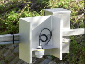
When the new compact radar level transmitter VEGAPULS C 11 became available,many of those problems vanished. The instrument contains a radar microchip that was optimised for the requirements of level measurement and, thanks to its high level of integration, makes it possible to build very compact sensors. The VEGAPULS C 11 measures with a frequency of 80 GHz, which enables very good signal focusing. This allows better separation of measurement signals from interference signals – measurement is thus much easier and more accurate than with other measuring methods, such as ultrasonics. And the very small beam angle of only 8° is ideal for the application. “Some channels are very small. Thanks to the narrow measuring beam, there are easier ways to install the sensor in tight spaces. For example, we can mount the sensor very close to the wall,” notes Eylenbosch. Thanks to its encapsulated cable and protection class IP66/68, the new radar sensor can be immersed in water in the event of a flood. Measurement data around the clock Every 15 minutes, the radar measurement is activated, and the measured value sent to the VMM database via a remote telemetry data logger. “This makes it possible to gain a better insight into our water supply and distribution reality and to calibrate our hydrological models,” explains Eylenbosch. Incidentally, any citizen can also access these data – the current readings can be viewed by anyone via the web service www.waterinfo.be. VMM procured 50 compact VEGAPULS C 11 radar level sensors and installed them with microcontrollers at numerous locations in five provinces. The exact location of each one is determined via a GPS module built into the data logger. “Most of the measuring points are located in open watercourses and are actually not problematic and we could also have used ultrasonic or pressure sensors. But the simple installation of the radar sensors via Bluetooth and the high measuring accuracy of ±5 mm, not to mention the very reasonable price, tipped the scales in favor of radar measurement technology. The instruments are also completely solar powered, which makes them even easier to operate and maintain. The significantly lower energy consumption of the new radar sensors was helpful to us in many respects,” says Eylenbosch. VEGAPULS C 11 fits into a small stainless-steel housing. “This makes the entire measurement setup so inconspicuous that it is also protected against vandalism and theft,” he adds. “We now have reliable, energy-efficient measurement 24 hours a day,” continues Eylenbosch, who is convinced that the need for additional measuring points will increase in the future. Expanding the sensor network is not a problem. A new level measuring point can be put into operation quickly and easily at any time and integrated into the existing network. As soon as the level measurement module is installed, the instrument goes online automatically. The administrator only has to fill out a few fields in a digital activation form beforehand – all subsequent measurement data are then automatically transferred to the database in a continuous stream. This ensures that the level data becomes quickly available on the data platform.