Trends, Milestones and Challenges
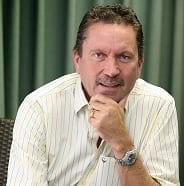
After 37 years as a scientist in the field of groundwater, and having just celebrated his 30th anniversary with SRK Consulting, partner and principal hydrogeologist Peter Rosewarne looks at some developments in the quantification, use and perception of this ubiquitous but often elusive resource; some personal and some national. Caption: 37 years in the science of groundwater – Peter Rosewarne, partner and principal hydrogeologist in SRK Consulting’s Cape Town office. Ranked among the twenty most water-scarce countries, South African water scientists and engineers have good reason to be interested in the extent, location and suitable management of the country’s groundwater resources, and how much of it may be sustainably developed into beneficial water supply. Because of the nature of 95 per cent of South Africa’s aquifers (hard rock, so-called secondary aquifers) hydrogeologists have long struggled to quantify how much groundwater is present and, more importantly, what is sustainably exploitable. This has often been much to the frustration of, not only hydrogeologists, but also engineers, who are used to getting straight answers to straight questions. When I became involved in hydrogeology in 1976, the estimates of South Africa’s exploitable groundwater resources, by the local pioneers of hydrogeology like Enslin and Vegter, were largely educated guesses (2.5 billion m3 by the way). By contrast, the publication, ‘Surface Water Resources of South Africa,’ was already well established and new editions were regularly being produced. Groundwater was perceived as being out of sight, unreliable and a poor relation of surface water, except where there was no alternative but to develop local groundwater resources. In this respect there are over 300 towns in SA that rely on groundwater as their main source of water supply. The Quest for Quantification In the 1970s and 1980s, we were still drawing maps using Letraset and Rötring pens (anyone remember them?), and the early researchers in this field had to do manual calculations where we today derive very rapid estimates from Geographical Information Systems (GIS). An average hydrogeologist today can do in a few weeks what it took the early pioneers a lifetime’s endeavour to achieve. In my early years in the sector, a key theme was the concern among hydrogeologists – as well as water resource engineers and planners – about the lack of systematic country-wide groundwater data collection, interpretation and quantification. This concern led to a series of groundwater mapping projects initiated by the Directorate of Geohydrology in the Department of Water Affairs and Forestry (DWAF) and the Water Research Commission in the 1990s. The former programme consisted of a series of 21 hydrogeological maps covering South Africa at a scale of 1:500 000, each with an explanatory booklet. The latter, by senior author J. R. Vegter, comprised of two A0 map sheets containing various scale maps depicting a more quantitative approach, including inter alia borehole prospects, saturated indices and recharge, also with an explanatory booklet.In 2003-2005 I was part of a team of hydrogeologists appointed by the DWAF to carry out the first comprehensive quantification of SA’s groundwater resources in the so-called Groundwater Resources Assessment Phase 2 Project. Using the full power of computing and GIS packages then available, new estimates of exploitable groundwater resources ranged from 19/16 (wet/dry years) billion m3 to 10/7 billion m3, the latter, lower figures taking into account constraints on exploitation such as quality and maximum allowable drawdown due to environmental issues.
Modelling Computers have brought great advances to the science, making the use of numerical models for predictive purposes both second nature and almost mandatory. The lack of this technology certainly goes some way to explaining why the estimates of groundwater resources made in the 1970s are so vastly different to those arrived at in 2005. In my early days at the DWAF, I remember a pioneer of numerical modelling in SA, Dr. Dave Bredenkamp, going about his arcane craft and sifting through reams of computer printouts. Nowadays, anyone can download a software package, press a few keys and get stuck into a user friendly Menu and start ‘modelling’. In the right hands they are very powerful tools. However, beware the unquestioning use or application of results from computer models. One of the key challenges in the application of numerical models and other computer-based programmes today is to educate the inexperienced (and sometimes the not-so-inexperienced) hydrogeologist to not just accept any old answer that the computer generates. Importance of groundwater There have also been changes in the way that groundwater use is viewed by authorities; earlier in my career, I made a proposal to the Water Engineer for Cape Town to look at the groundwater resources of the Table Mountain Group (TMG) sandstones. These rocks form one of the few Major Aquifers in South Africa. It was dismissed rather disdainfully, as the possible resources were considered just “a drop in the ocean”. I thought, it may be a drop, relatively speaking, but it’s on our doorstep, not in the ocean! It therefore came as no surprise when the City embarked on a comprehensive groundwater exploration programme of the TMG Aquifer in 2002. Heading down the home straight of my career there are some exciting developments ahead. One is the very detailed assessment of Karoo Aquifers that will be required as part of the exploration for shale gas in the Great Karoo. This research work has the potential to add immensely to our understanding and use of these unique aquifers, and potentially inspire a new generation of unique aquifers, and potentially inspire a new generation of hydrogeologists. Peter Rosewarne is a partner in SRK Consulting’s Cape Town office, which has done groundwater work in about 20 countries to date, including Saudi Arabia, Chile, India, Suriname and Mali. Technical expertise is held in the fields of supply, monitoring, mining, contamination and energy applications.

