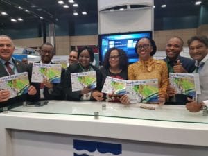

Minister of Water and Sanitation Nomvula Mokonyane (centre) and CEO of the Water Research Commission, Dhesigen Naidoo (far right) with ministers and delegates from throughout Africa during the launch of the Mine Water Atlas at the ICC in Durban.
Multi-layered maps
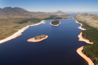
The atlas has a multi-layered set of maps which span all mineral provinces in South Africa and highlights areas where mining frequently takes place.
The maps chart water resources in the various provinces and are overlaid with maps of mining and mineral-refining activities in order to understand the locations at which surface and groundwater and mining collide.
The WRC said that the atlas is intended to help mining companies, investors, government departments and students get a better understanding of the impact of mining on water resources. “While it is an extremely useful guide, the atlas does not replace Environmental Impact Assessments (EIAs) or tell you where you can or can’t mine, but assists with the decision-making process around the likely impacts of mining activity in a given mineral region,” the WRC said in a statement. It added that the atlas can be used to see what potential liabilities may be and what the focus of mitigation measures may need to be in order to protect water resources in an area of operation. “For example, water treatment plants may be needed to ensure water discharges from the mines are of good quality and won’t damage the environment or pose a risk to public health,” the WRC said.Mining and water pollution problems
Mining often comes under the spotlight for water pollution problems. The WRC explained that uncontrolled discharges of acid, neutral, and saline mining-impacted water can have a devastating effect on surface and ground water resources. “Acidic water leaching out of mine dumps can flow into rivers or streams, stop plants from growing and kill the food chain from the bottom up,” the WRC said. “When left unchecked, the dirty water generated from mining activities finds its way into surface water features such as rivers and wetlands, negatively impacting both downstream users and the aquatic environment. The WRC added that the atlas will:- Help government departments visualise and highlight areas that are very risky, and help define key questions for impact assessments.
- It will serve as an educational reference for legislators and universities.
- It is geared towards raising awareness among the public about the critical link between water and mining.