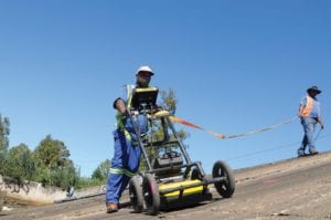
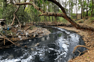
The data reported from a ground-penetrating radar survey will help to pinpoint anomalies in the concrete spillway structure at Middle Lake, which recently suffered significant erosion damage. This emergency situation required urgent action to reduce the risk of potential failure of the spillway to acceptable levels.
Benoni’s 4.22 km long Middle Lake forms part of a series of four interconnecting dams, the oldest of which is known as Homestead Lake. Their establishment dates to around 1896, when they were progressively built to support the region’s booming gold mining industry. Bordering the N12 national route, they currently mostly serve as flood control facilities for Ekurhuleni residents living in the area, in addition to sustaining the surrounding wetlands for which this region is well known. These Category 2 earth-fill dams are all registered with the Dam Safety Office, under the Department of Water and Sanitation. In terms of the dam safety regulations, Category 2 structures need to be inspected every five years by an approved professional person (APP), which has been the case for Middle Lake and its sister dams. (The interval period may be extended by the Director-General of the DWS, depending on the status of the dam.) An APP is normally a registered professional person, such as a civil engineer, with advanced specialisation in dam engineering and dam safety, and approved by the Engineering Council of South Africa for this task. The last major maintenance intervention at Middle Lake took place during 2004, which entailed repairs to the dam’s concrete spillway. Cracks and joints were sealed, and cavities grouted. To prevent seepage, a vertical cut-off concrete beam was also installed at full supply level. On 23 December 2018, a concrete slab section on Middle Lake’s spillway suddenly caved in during a period of particularly heavy rainfall. The collapse of the concrete slab was unexpected and needed an urgent intervention to prevent further weakening of the overall spillway structure and its potential collapse. Full credit is due to a number of officials of the Ekurhuleni Roads and Stormwater Department, such as Alice Chauque and Philip Nice, supported by Ekurhuleni Disaster and Emergency Management Services, for their quick reaction and the ensuing mobilisation of a joint operations committee (JOC) to coordinate and oversee the action plan to deal with the emergency. Ekurhuleni Municipality was strongly supported by officials and experts from the DWS, DWS Gauteng Region, DWS Construction, the Gauteng Department of Agriculture and Rural Development, and Rand Water, to name a few. Sandbags were immediately installed to divert and channel the force of the water around the damaged area on the spillway. Siphon suction pumps were then installed to reduce the dam level and keep the spillway clear for damage assessment and the ensuing remedial interventions. In Phase I, the exposed gap was repaired as part of the emergency repair. The Phase I work to the spillway was completed in February 2019 to the satisfaction of all authorities concerned.Ground-penetrating radar investigation
Henriette Anderson, as a team member of consulting engineering firm Delta Built Environment Consultants, was appointed as the APP to carry out the condition assessment and optimum repair methodology forming the second and final phase of the works. To ensure a high degree of accuracy, Benoni-based specialist subcontractor ORSCO was appointed to complete a full survey investigation of the spillway and stilling basin using GPR (ground-penetrating radar) technology to map potential shallow voids underneath the concrete slabs covering the earth-fill spillway and flaws in the concrete slabs covering the spillway and stilling basin.“Radar is very accurate and an excellent way to ‘X-ray’ structures, as well as to detect underground services such as water and sewer pipelines,” explains Darek Leskiewicz, senior consultant: GPR at ORSCO, a 6 CE CIDB contractor. “As a non-destructive methodology, it minimises the need for open-cut or core drilling during investigation and facility condition assessments, which also lowers overall project costs.”
The basic principle of GPR is the transmission of a short electromagnetic pulse, with a specified frequency, into the ground and the recording of reflected energy as a function of time, amplitude and phase. The reflected energy is recorded as a pattern on radar grams displayed in real time. The recorded data can then be processed and analysed off-site using specialised software to produce 3D subsurface maps. A series of GPR grids and depth slices were collected during the survey, which were divided into three sections, namely the top of the spillway, the slope of the spillway, and the stilling basin. These slices were captured at progressive depths of up to 5 m. The results from each stage were combined to create one super grid for easier data processing and interpretation. The client will be able to use this data to pinpoint where further testing is required. This might include selective core drilling to confirm the extent of identified anomalies. That will then confirm the extent and cost of the engineering interventions required. “The primary concern is to ensure the safety and structural integrity of the dam and the safety of those downstream,” explains Anderson. Thanks to GPR, Ekurhuleni Municipality will have a high degree of certainly about the repairs needed in Phase II, which should significantly shorten the construction time to fully repair the erosion damage to the Middle Dam spillway. It will also enable a more cost-effective approach for extending the life of this structure, rather than demolishing it completely and reconstructing. “Worldwide, GPR has certainly revolutionised the way municipal engineers inspect and maintain a wide range of infrastructure services. As in Middle Dam’s case, it has certainly proved to be an invaluable tool,” adds Leskiewicz. The Middle Lake Dam emergency situation and the repairs that had to be undertaken taught the Ekurhuleni Roads and Stormwater Department officials invaluable lessons (both on a technical and corporate governance level), which would not have been possible had it not been for the assistance of professionals and officials from other departments within the city, as well as departments from other spheres of government. The Roads and Stormwater Department wishes to acknowledge each and every person that contributed (whether minorly or majorly) to finding solutions to fixing the Middle Lake Dam wall and to everyone who put their trust in the department to deal with the matter.


