Modelling in the water sector contributes to efficient resource management, improved infrastructure design, and better decision-making – ultimately leading to sustainable water use and environmental conservation.
By Kerry Grimmer, principal hydrologist, SRK Consulting
Water resource hydrological and yield modelling involves the use of mathematical and computational models to simulate the movement, distribution, and availability of water in a specific area.
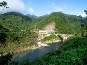
For example, the yield of a dam is defined as the maximum amount of water that it can supply without failing (emptying). Yield analyses are essential in the construction of dams and the development of operating rules for water supply systems, including independent dams or inter-connected water systems.
Modelling is also vital to the sizing and designing of a potential dam as it factors in the growth in water requirements due to growing population or developing industry. A large focus area for SRK is mining; and therefore, the planning of water availability and supply is crucial, as these operations can have lifespans of decades.
Data
When carrying out water resources modelling, the results can be skewed by any of the input data. Rainfall and streamflow data are the most crucial aspects; however, all data needs to accurately represent the catchment in order to obtain accurate results. There are complexities with this requirement. For example, when determining the rainfall over a catchment, it needs to be representative of a larger area than just point rainfall at a rainfall station. Therefore, the rainfall data needs to be both spatially and temporally representative, and without missing and/or suspect values. This is often difficult to achieve due to sparse historical records.
Having accurate and in-depth hydrological data – most notably streamflow and rainfall data – is key to accurate modelling. This data must mimic the situation on the ground over a given historic period to ensure that the model is mimicking the correct rainfall-response of the catchment. Rainfall and streamflow data can be obtained from meteorological/water governmental departments of the country of interest. There are also several worldwide freely available sources of satellite and/or observed rainfall data. These resources are commonly used when site-specific data is sparse, missing, or suspect. Other data required includes reservoir information, land use (such as irrigation areas and crop types), afforestation, alien vegetation, as well as any water requirements in the system, including urban, rural, mining, industrial, and inter-catchment transfers.
Historic data is used to model historic conditions of the catchment over a specific period of time. The results can then be used to assess, for example, alternative scenarios to predict changes in streamflow, or feed into other models to predict future water availability. The input data determines the accuracy of the results obtained and is therefore imperative to a project.
 Climate change
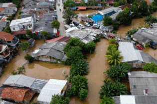
However, climate change alters precipitation patterns, leading to shifts in the timing, intensity, and distribution of rainfall. The potential impacts of climate change place a larger amount of uncertainty on projections of rainfall, runoff, and subsequent yield analyses, therefore affecting the design, planning, and operating of dams.
Stochastic models are used to analyse rainfall and streamflow, but they are somewhat limited to the base historic data. Changes in the hydrological regime (both natural and anthropogenic) include variations in annual rainfall (quantity), rainfall patterns (seasonal shifts), intensity (flood/drought events), and spatial distribution. The cumulative impacts of these changes could significantly impact streamflow, and subsequently the yield of a dam or system.
Climate change
However, climate change alters precipitation patterns, leading to shifts in the timing, intensity, and distribution of rainfall. The potential impacts of climate change place a larger amount of uncertainty on projections of rainfall, runoff, and subsequent yield analyses, therefore affecting the design, planning, and operating of dams.
Stochastic models are used to analyse rainfall and streamflow, but they are somewhat limited to the base historic data. Changes in the hydrological regime (both natural and anthropogenic) include variations in annual rainfall (quantity), rainfall patterns (seasonal shifts), intensity (flood/drought events), and spatial distribution. The cumulative impacts of these changes could significantly impact streamflow, and subsequently the yield of a dam or system.

 Trends
While complex hydrological systems have been modelled for many years, it has become increasingly important to incorporate the protection of natural water resources and the broader environment into models. South Africa is a water scarce country, and the growing demands of people, agriculture and industry can risk changing the ecology of river systems.
If the flow of a river system is significantly altered or depleted, it could have catastrophic effects on the natural biodiversity of its environment. The natural ecosystem of a river requires flows which are as close to natural conditions as possible, including flow volumes, streamflow patterns (such as seasonal variation), and quality in order to maintain its integrity. Dams fundamentally change the natural flow of a river by impounding water which would have otherwise flowed downstream. For this reason, ecological water requirements are necessary, which are flows required to remain in the river in order to maintain the natural ecosystem as much as possible, including vegetation, insects, amphibians, fish, and other living organisms.
Ecological water requirements are very specific to each system and must be determined individually for each river reach or site for a project. As a consequence of ecological requirements, the yield of a dam will decrease, as not all water is available for use/storage. Therefore, the implementation of the ecological requirements can drastically decrease the yield to a point of making the system impractical, as water demands may no longer be fully supplied. This is where a balance needs to be established, between maintaining the ecological integrity of the river and abstracting sufficient water to meet the demands.
SRK believes that the delicate balance between development/economic growth and the protection of our natural resources needs to be maintained. Ecological requirements are unique to a site, and depending on the situation, they are not always required. For example, if a system (catchment) is very small, the resource may not be considered significant in terms of ecology. SRK includes ecological water requirements in applicable water supply projects, to ensure that we are also addressing and protecting the environmental integrity of the river system under analysis. For example, SRK is currently doing a study for a very small stream with a weir which has nominal storage. The benefits of using the water for urban supply may outweigh the benefits of releasing water for the ecology of the river. In this example, the stream does not contribute sufficient flow to the downstream river system to have a significant effect. Therefore, implementing ecological flows may cause a scenario which is impractical or even unrealistic.
Available software
In South Africa there are various models available for water resources modelling, including hydrological, yield, and planning modelling. There are freely available models which have been developed by South African consultants, universities, and governmental institutions, as well as international models which have been developed overseas. For water supply projects, SRK focuses on the most widely used models, which are sometimes even stipulated in tenders.
The Pitman Model (also known as WRSM2000), focuses on the modelling of historic periods in order to calibrate the model against observed streamflow through a number of catchment-specific characteristics. The model is primarily used for streamflow analysis, using a deterministic approach based upon historic data. The objective is to obtain a model which accurately reflects the rainfall-runoff response of the catchment, and the system can then be used and manipulated for additional scenarios. As these are the most commonly used models, the output from the Pitman Model also feeds into other models.
The Water Resources Yield Model, however, is used for determining long- or short-term dam/system yields with more a complex reservoir analysis. The primary difference between the two models is that the yield model is a stochastic model and is therefore able to generate many different hydrological streamflow scenarios and is not based solely on historic data.
Different user groups, such as urban, agriculture, industrial, etc., require water at different levels of assurance, meaning some have a higher priority than others. The yield model is able to determine different yields at different assurances of supply, which makes long-term planning more accurate. For example, agricultural supply can fail (i.e., not get their full amount of water) more often than urban supply; therefore, urban demands are supplied at a higher level of assurance. The yield model can also be used for short-term analyses, which enables dam operators to effectively manage their resources based upon the current level of the dam. This is particularly important during low rainfall or drought periods when restrictions need to be implemented.
Trends
While complex hydrological systems have been modelled for many years, it has become increasingly important to incorporate the protection of natural water resources and the broader environment into models. South Africa is a water scarce country, and the growing demands of people, agriculture and industry can risk changing the ecology of river systems.
If the flow of a river system is significantly altered or depleted, it could have catastrophic effects on the natural biodiversity of its environment. The natural ecosystem of a river requires flows which are as close to natural conditions as possible, including flow volumes, streamflow patterns (such as seasonal variation), and quality in order to maintain its integrity. Dams fundamentally change the natural flow of a river by impounding water which would have otherwise flowed downstream. For this reason, ecological water requirements are necessary, which are flows required to remain in the river in order to maintain the natural ecosystem as much as possible, including vegetation, insects, amphibians, fish, and other living organisms.
Ecological water requirements are very specific to each system and must be determined individually for each river reach or site for a project. As a consequence of ecological requirements, the yield of a dam will decrease, as not all water is available for use/storage. Therefore, the implementation of the ecological requirements can drastically decrease the yield to a point of making the system impractical, as water demands may no longer be fully supplied. This is where a balance needs to be established, between maintaining the ecological integrity of the river and abstracting sufficient water to meet the demands.
SRK believes that the delicate balance between development/economic growth and the protection of our natural resources needs to be maintained. Ecological requirements are unique to a site, and depending on the situation, they are not always required. For example, if a system (catchment) is very small, the resource may not be considered significant in terms of ecology. SRK includes ecological water requirements in applicable water supply projects, to ensure that we are also addressing and protecting the environmental integrity of the river system under analysis. For example, SRK is currently doing a study for a very small stream with a weir which has nominal storage. The benefits of using the water for urban supply may outweigh the benefits of releasing water for the ecology of the river. In this example, the stream does not contribute sufficient flow to the downstream river system to have a significant effect. Therefore, implementing ecological flows may cause a scenario which is impractical or even unrealistic.
Available software
In South Africa there are various models available for water resources modelling, including hydrological, yield, and planning modelling. There are freely available models which have been developed by South African consultants, universities, and governmental institutions, as well as international models which have been developed overseas. For water supply projects, SRK focuses on the most widely used models, which are sometimes even stipulated in tenders.
The Pitman Model (also known as WRSM2000), focuses on the modelling of historic periods in order to calibrate the model against observed streamflow through a number of catchment-specific characteristics. The model is primarily used for streamflow analysis, using a deterministic approach based upon historic data. The objective is to obtain a model which accurately reflects the rainfall-runoff response of the catchment, and the system can then be used and manipulated for additional scenarios. As these are the most commonly used models, the output from the Pitman Model also feeds into other models.
The Water Resources Yield Model, however, is used for determining long- or short-term dam/system yields with more a complex reservoir analysis. The primary difference between the two models is that the yield model is a stochastic model and is therefore able to generate many different hydrological streamflow scenarios and is not based solely on historic data.
Different user groups, such as urban, agriculture, industrial, etc., require water at different levels of assurance, meaning some have a higher priority than others. The yield model is able to determine different yields at different assurances of supply, which makes long-term planning more accurate. For example, agricultural supply can fail (i.e., not get their full amount of water) more often than urban supply; therefore, urban demands are supplied at a higher level of assurance. The yield model can also be used for short-term analyses, which enables dam operators to effectively manage their resources based upon the current level of the dam. This is particularly important during low rainfall or drought periods when restrictions need to be implemented.
 Climate change
However, climate change alters precipitation patterns, leading to shifts in the timing, intensity, and distribution of rainfall. The potential impacts of climate change place a larger amount of uncertainty on projections of rainfall, runoff, and subsequent yield analyses, therefore affecting the design, planning, and operating of dams.
Stochastic models are used to analyse rainfall and streamflow, but they are somewhat limited to the base historic data. Changes in the hydrological regime (both natural and anthropogenic) include variations in annual rainfall (quantity), rainfall patterns (seasonal shifts), intensity (flood/drought events), and spatial distribution. The cumulative impacts of these changes could significantly impact streamflow, and subsequently the yield of a dam or system.
Climate change
However, climate change alters precipitation patterns, leading to shifts in the timing, intensity, and distribution of rainfall. The potential impacts of climate change place a larger amount of uncertainty on projections of rainfall, runoff, and subsequent yield analyses, therefore affecting the design, planning, and operating of dams.
Stochastic models are used to analyse rainfall and streamflow, but they are somewhat limited to the base historic data. Changes in the hydrological regime (both natural and anthropogenic) include variations in annual rainfall (quantity), rainfall patterns (seasonal shifts), intensity (flood/drought events), and spatial distribution. The cumulative impacts of these changes could significantly impact streamflow, and subsequently the yield of a dam or system.
Although climate change has been studied for decades, it is difficult to input accurate information into the models. A certain amount of flexibility in operating rules is fundamental in addressing fluctuating and unpredictable hydrological conditions and reducing the associated negative implications. For this reason, different scenarios are usually analysed, often derived from the Intergovernmental Panel on Climate Change (IPCC). These may often represent “best case” and “worst case” scenarios. Historic rainfall data cannot yet fully incorporate the changes in climate when carrying out long-term analyses, which causes a greater uncertainty in predicting future hydrology.
It is imperative that changes in climate be incorporated into water resources modelling by assessing various projected climate scenarios and determining the effect and consequences of these changes. Studies need to be updated to ensure that the changes in climate are being incorporated into system analyses. From this, we can then project more accurate assessments of river flows and dam yields, while also developing strategic responses and adaptation measures to the potential negative impacts of climate change, essentially with the goal to “climate proof” our water resources. Trends
While complex hydrological systems have been modelled for many years, it has become increasingly important to incorporate the protection of natural water resources and the broader environment into models. South Africa is a water scarce country, and the growing demands of people, agriculture and industry can risk changing the ecology of river systems.
If the flow of a river system is significantly altered or depleted, it could have catastrophic effects on the natural biodiversity of its environment. The natural ecosystem of a river requires flows which are as close to natural conditions as possible, including flow volumes, streamflow patterns (such as seasonal variation), and quality in order to maintain its integrity. Dams fundamentally change the natural flow of a river by impounding water which would have otherwise flowed downstream. For this reason, ecological water requirements are necessary, which are flows required to remain in the river in order to maintain the natural ecosystem as much as possible, including vegetation, insects, amphibians, fish, and other living organisms.
Ecological water requirements are very specific to each system and must be determined individually for each river reach or site for a project. As a consequence of ecological requirements, the yield of a dam will decrease, as not all water is available for use/storage. Therefore, the implementation of the ecological requirements can drastically decrease the yield to a point of making the system impractical, as water demands may no longer be fully supplied. This is where a balance needs to be established, between maintaining the ecological integrity of the river and abstracting sufficient water to meet the demands.
SRK believes that the delicate balance between development/economic growth and the protection of our natural resources needs to be maintained. Ecological requirements are unique to a site, and depending on the situation, they are not always required. For example, if a system (catchment) is very small, the resource may not be considered significant in terms of ecology. SRK includes ecological water requirements in applicable water supply projects, to ensure that we are also addressing and protecting the environmental integrity of the river system under analysis. For example, SRK is currently doing a study for a very small stream with a weir which has nominal storage. The benefits of using the water for urban supply may outweigh the benefits of releasing water for the ecology of the river. In this example, the stream does not contribute sufficient flow to the downstream river system to have a significant effect. Therefore, implementing ecological flows may cause a scenario which is impractical or even unrealistic.
Available software
In South Africa there are various models available for water resources modelling, including hydrological, yield, and planning modelling. There are freely available models which have been developed by South African consultants, universities, and governmental institutions, as well as international models which have been developed overseas. For water supply projects, SRK focuses on the most widely used models, which are sometimes even stipulated in tenders.
The Pitman Model (also known as WRSM2000), focuses on the modelling of historic periods in order to calibrate the model against observed streamflow through a number of catchment-specific characteristics. The model is primarily used for streamflow analysis, using a deterministic approach based upon historic data. The objective is to obtain a model which accurately reflects the rainfall-runoff response of the catchment, and the system can then be used and manipulated for additional scenarios. As these are the most commonly used models, the output from the Pitman Model also feeds into other models.
The Water Resources Yield Model, however, is used for determining long- or short-term dam/system yields with more a complex reservoir analysis. The primary difference between the two models is that the yield model is a stochastic model and is therefore able to generate many different hydrological streamflow scenarios and is not based solely on historic data.
Different user groups, such as urban, agriculture, industrial, etc., require water at different levels of assurance, meaning some have a higher priority than others. The yield model is able to determine different yields at different assurances of supply, which makes long-term planning more accurate. For example, agricultural supply can fail (i.e., not get their full amount of water) more often than urban supply; therefore, urban demands are supplied at a higher level of assurance. The yield model can also be used for short-term analyses, which enables dam operators to effectively manage their resources based upon the current level of the dam. This is particularly important during low rainfall or drought periods when restrictions need to be implemented.
Trends
While complex hydrological systems have been modelled for many years, it has become increasingly important to incorporate the protection of natural water resources and the broader environment into models. South Africa is a water scarce country, and the growing demands of people, agriculture and industry can risk changing the ecology of river systems.
If the flow of a river system is significantly altered or depleted, it could have catastrophic effects on the natural biodiversity of its environment. The natural ecosystem of a river requires flows which are as close to natural conditions as possible, including flow volumes, streamflow patterns (such as seasonal variation), and quality in order to maintain its integrity. Dams fundamentally change the natural flow of a river by impounding water which would have otherwise flowed downstream. For this reason, ecological water requirements are necessary, which are flows required to remain in the river in order to maintain the natural ecosystem as much as possible, including vegetation, insects, amphibians, fish, and other living organisms.
Ecological water requirements are very specific to each system and must be determined individually for each river reach or site for a project. As a consequence of ecological requirements, the yield of a dam will decrease, as not all water is available for use/storage. Therefore, the implementation of the ecological requirements can drastically decrease the yield to a point of making the system impractical, as water demands may no longer be fully supplied. This is where a balance needs to be established, between maintaining the ecological integrity of the river and abstracting sufficient water to meet the demands.
SRK believes that the delicate balance between development/economic growth and the protection of our natural resources needs to be maintained. Ecological requirements are unique to a site, and depending on the situation, they are not always required. For example, if a system (catchment) is very small, the resource may not be considered significant in terms of ecology. SRK includes ecological water requirements in applicable water supply projects, to ensure that we are also addressing and protecting the environmental integrity of the river system under analysis. For example, SRK is currently doing a study for a very small stream with a weir which has nominal storage. The benefits of using the water for urban supply may outweigh the benefits of releasing water for the ecology of the river. In this example, the stream does not contribute sufficient flow to the downstream river system to have a significant effect. Therefore, implementing ecological flows may cause a scenario which is impractical or even unrealistic.
Available software
In South Africa there are various models available for water resources modelling, including hydrological, yield, and planning modelling. There are freely available models which have been developed by South African consultants, universities, and governmental institutions, as well as international models which have been developed overseas. For water supply projects, SRK focuses on the most widely used models, which are sometimes even stipulated in tenders.
The Pitman Model (also known as WRSM2000), focuses on the modelling of historic periods in order to calibrate the model against observed streamflow through a number of catchment-specific characteristics. The model is primarily used for streamflow analysis, using a deterministic approach based upon historic data. The objective is to obtain a model which accurately reflects the rainfall-runoff response of the catchment, and the system can then be used and manipulated for additional scenarios. As these are the most commonly used models, the output from the Pitman Model also feeds into other models.
The Water Resources Yield Model, however, is used for determining long- or short-term dam/system yields with more a complex reservoir analysis. The primary difference between the two models is that the yield model is a stochastic model and is therefore able to generate many different hydrological streamflow scenarios and is not based solely on historic data.
Different user groups, such as urban, agriculture, industrial, etc., require water at different levels of assurance, meaning some have a higher priority than others. The yield model is able to determine different yields at different assurances of supply, which makes long-term planning more accurate. For example, agricultural supply can fail (i.e., not get their full amount of water) more often than urban supply; therefore, urban demands are supplied at a higher level of assurance. The yield model can also be used for short-term analyses, which enables dam operators to effectively manage their resources based upon the current level of the dam. This is particularly important during low rainfall or drought periods when restrictions need to be implemented.