Data sources for SA
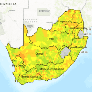
The new water risk map and higher resolution water risk data for South Africa draws on a number of different nationally available datasets. These include the Department of Water and Sanitation’s All Towns Reconciliation Studies, the CSIR’s downscaled climate change data, the Water Research Commission’s WR2012 and the Water User Licencing Registration and Revenue Collection registered surface water use to determine surface and groundwater scarcity across the country. These national indicators are equivalent to existing global level indicators, but are not identical so they do not necessarily use the same units or metrics as the global indicators. However, in broad terms, they provide similar information on the characteristics of the water environment. Water Risk Filter WWF designed the Water Risk Filter to help companies assess water-related risks within their own operations, suppliers or growth plans. It is a simple tool designed for non-water experts and provides a structured set of risk indicators with very limited information needed from the user. The tool addresses different elements of water risk, all industries (standard classifications) and all countries of the world, with the South African version providing you with an option to use local data for a locally nuanced assessment. It interprets the best available scientific data for you and translates it into risk numbers based on a questionnaire. This will indicate whether the highest risks are faced in the operations or the broader basin, and are present as physical, reputational or governance based risks. Users can then map the assessed facilities or investments on numerous water-related map overlays. Finally, a structured set of responses and up-to-date case studies will give you a flying start in mitigating risk and developing a water stewardship strategy.
The World Wildlife Fund (WWF) has released new data on South Africa’s water and risk-related areas.
Over the past several months, South Africa has been hit with the effects of its worst drought since 1992. The result is movement in the private sector towards understanding its water risk and working with others to mitigate shared risks.
In line with this, WWF has launched new high resolution data for South Africa that will now help farmers and businesses understand how their water risk varies across the South African landscape.
This data forms part of WWF’s Water Risk Filter which was developed back in 2012. It is the first tool to quantify water-related risks for all industries in all countries at a global level and is ideal for large multinationals wanting to assess water risk in different parts of the world.
The new South African risk maps incorporate local datasets at a finer-scale, providing the user with a country-specific more granular view of water risk.
WWF has used the best freely available, peer reviewed, nationally consistent data on water for South Africa to develop s indicators for physical, reputational and regulatory water risk. As more datasets are made available, and updates to existing datasets are made, the organisation will periodically update and expand the South African datasets.
The Water Risk Filter also provides users with guidance on best practice and how to implement mitigatory actions, thus helping business take the first step on their water stewardship journey.


