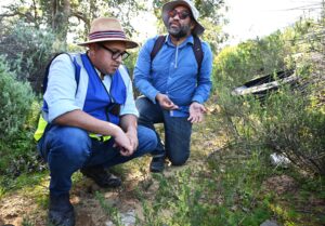
The City’s Mayoral Committee Member for Water and Sanitation, Councillor Zahid Badroodien joined the newly established Diep River Catchment Management Forum (DRCMF) for a walk along the Diep River on Tuesday.
As part of its Mayoral Priority Programme (MPP) the Water and Sanitation Directorate aims to establish Catchment Management Forums (CMFs) in areas where community partnership and joint interventions to improve inland water quality are needed. The DRCMF held its inaugural meeting on 29 June 2024 where Rupert Koopman was elected as the interim Chair, and Petra Broddle the interim Deputy Chair, both with professional expertise in botany. The immediate priorities of the DRCMF are to focus on identifying social and environmental factors negatively affecting river management; to find solutions together with all members of the forum and surrounding communities, to the urban, agricultural, commercial and industrial pollution which ends up in vital watercourses.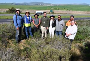
A walk along the Diep River. From left: DRCF Chairperson Rupert Koopman, Councillor Zahid Badroodien, Motlatsi Christian Nkhoesa, Kobus Delport, Kloey Bam, Gavin Joachims, Khwezi Mahlungulu and Deputy Chairperson Petra Broddle.
- The catchment spans across just over 1500km², of which almost 700km² lies within the City of Cape Town’s municipal jurisdiction; while the remainder lies in the Cape Winelands District and West Coast District municipalities.
- The Mosselbank River is the biggest tributary of the Diep River, rising in the Drakenstein Municipality along Old Paarl Road and the R304, and then crosses the N1 into Cape Town.
- The confluence of the Mosselbank and the Diep River is along Philadelphia Road. It flows towards the N7, past Vissershok Landfill, Table View informal housing sites and industrial areas towards the sea at Lagoon Beach, north of Paarden Eiland. The last part of the river, south of Dunoon, lies within the Table Bay Nature Reserve.
- A Dunoon/Doornbach Stormwater Study to assess water quality discharging into the Diep River and to analyse the existing stormwater drainage system. Various mitigation measures are being reviewed as Dunoon and Doornbach are high density, low-income, informal residential areas located adjacent to the Diep River. One main consideration is the Kleine Stink River’s floodplains which have informal dwellings situated within them and relocation is a major challenge. For this reason, the study is assessing the feasibility of re-routing the Kleine Stink River away from the informal dwellings and discharging further upstream into the Diep River.
- Upgrading the Milky Way/Joe Slovo pond which is currently in the detailed design phase, as part of the rehabilitation of the Diep River. A City-appointed service provider is developing interventions including improvements to the Milky Way Pond and the Erica Road stormwater system and outfall.
- The Erica Road low-flow diversion is an initiative that came out of the Milky Way pond concept design. The low-flow diversion structure is located at the R27, behind Milnerton High School. Construction work was completed in July 2023. The low-flow diversion system is now fully operational, diverting polluted stormwater from Joe Slovo and Phoenix to the sewer system.
- The Bayside Canal Upgrade aims to increase the capacity of the Bayside canal, to provide naturally-structured treatment facilities which improve the quality of stormwater runoff that flows from the canal into the Rietvlei, and to provide adequate access for systematic maintenance in the future.
- Installing litter nets, where currently twenty two litter nets across outlets of stormwater pipes crossing Marine Drive are in place, to trial their efficacy in trapping general waste. A litter fence has also been installed across a channel downstream of the piped stormwater outlets to intercept litter before the flow enters the Diep River.
 ‘This is the first of a series of river walks I will be doing with the various CMFs that have been established over the last few months. It was lovely meeting the executive of the DRCMF and gaining insight into some of the challenges faced in the catchment, such as high-density informal settlements and a lack of water-balance in many residential areas.
Managing a waste water network that is constantly under pressure and poor water quality entering the river in general is a major concern. Establishing platforms for our operational teams to working together with community members, drawing on a wider pool of professional expertise, is a step forward in our strategic commitment to preserving Cape Town’s water resources. We look forward to seeing more of these forums being established across the city where they are much needed in the urban environment,’ said Councillor Badroodien.


