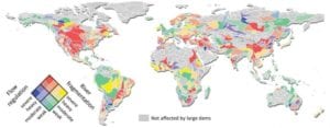
A new method to estimate the global impacts of dams on river flow and fragmentation has been developed by a group of international researchers, led by McGill University researchers.
The new research, which may influence dam planning strategies, was made possible by the team’s development of a global river map with unprecedented resolution and detail. The map shows all waterways of the world from small creeks to the largest of rivers and it includes a new map of future dam locations assembled by colleagues at the Leibniz-Institute of Freshwater Ecology and Inland Fisheries in Berlin. Among their findings, published online yesterday in Environmental Research Letters: 48% of the world’s river volume is moderately or severely affected by dams today – and that figure would nearly double if all dams planned or under construction are completed in the future.“Over the past 60 years, a myriad of dams have been built either to provide hydroelectric power, or for irrigation purposes, or as flood protection,” says Bernhard Lehner, a professor in McGill University’s Department of Geography and the research director of the project.
“The construction of large dams then slowed down for the last 20 years as we became more aware of their negative effects on people and ecosystems. But now, with fears about how climate change may affect water flows in the future, the goal of creating reservoirs is once more appealing, and dam construction is on the rise.” According to Günther Grill, a postdoctoral fellow in McGill University’s Department of Geography their research assumes that it is not only the size of a dam but also where it is placed along the river that makes a difference. Click here to read part 2


